


iNavX
Marine Navigation

คำอธิบายของiNavX: Marine Navigation
การนำทางทางทะเลทำได้ง่ายด้วย iNavX - Chartplotter แบบพกพาอันดับ 1 ของโลก เข้าถึงแผนภูมิทางทะเล แผนที่ สภาพอากาศ AIS และอีกมากมาย!
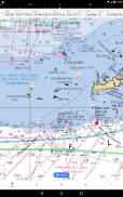
iNavX เป็นแอปเดียวที่ให้คุณครอบคลุมแผนภูมิทั่วโลกได้อย่างสมบูรณ์ จากผู้ให้บริการแผนภูมิที่คุณชื่นชอบทั้งหมด รวมถึง iNavX Professional+ Global Chart ใหม่ทั้งหมด! เปิดใช้งานอย่างเต็มรูปแบบด้วยการเข้าถึงด้วยการแตะเพียงครั้งเดียว iNavX ให้ผู้ใช้เข้าถึงชุดแผนภูมิและแผนที่ทางทะเลที่กว้างที่สุดจากผู้ให้บริการหลายรายรวมถึง:
• แผนภูมิ iNavX Professional+
• ละติจูดสีน้ำเงิน
• สำรวจ
• สภาพอากาศของพวกเขา
• คู่มือทางน้ำ
• … และอื่น ๆ
iNavX ยกระดับการนำทางทางทะเลแบบใช้มือถือไปอีกระดับได้อย่างไร
• กะลาสี - วางแผนเส้นทางการเดินเรือด้วยจุดอ้างอิงและการจัดการเส้นทาง รับการจัดการการแล่นเรือเชิงรุกด้วยการพยากรณ์อากาศของ GRIB จากนั้นคอยดูด้วยโอเวอร์เลย์ AIS และการรวมเข้ากับระบบออนบอร์ดของคุณ นอกจากนี้ คุณยังจำสถานที่ล่องเรือที่ยอดเยี่ยมได้ด้วยการติดแท็กตำแหน่งรูปภาพ
• นักพายเรือ - ติดตามข้อมูลล่าสุดเกี่ยวกับสภาพการพายเรือด้วยการคาดการณ์ซึ่งรวมถึงกระแสน้ำ ลม และคลื่น จัดการอุปกรณ์พายเรือของคุณด้วยการรวมอุปกรณ์เกี่ยวกับการเดินเรือ จากนั้นบันทึกเส้นทางการพายเรือที่ยอดเยี่ยมเพื่อแชร์กับบันทึกการติดตาม
• นักตกปลา - ค้นพบจุดตกปลาใหม่ๆ โดยการสำรวจหลุมและปากน้ำ ค้นหาสภาพการตกปลาที่ดีที่สุดโดยระบุแนวรบที่หนาวเย็นและบันทึกจุดตกปลาที่ดีที่สุดของคุณด้วยเครื่องหมายไม่จำกัด
คุณสมบัติขั้นสูง - iNavX เป็นแอพที่มีคุณสมบัติครบถ้วนที่สุดสำหรับทุกความต้องการในการแล่นเรือใบและพายเรือในราคาสุดคุ้ม:
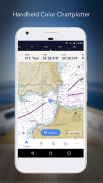
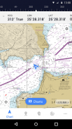
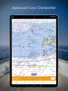
พล็อตเตอร์แผนภูมิขั้นสูง
• พล็อตตำแหน่งของคุณแบบเรียลไทม์โดยใช้ GPS ในตัวของอุปกรณ์
• แพน ซูม และหมุนแผนภูมิ (รวมถึงหลักสูตร)
• พิมพ์แผนภูมิรายละเอียดเพื่อใช้ร่วมกับแอป
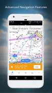
การนำทางขั้นสูง
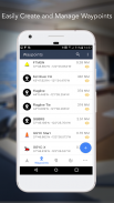
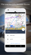
• สร้างจุดอ้างอิงและวางแผนเส้นทางเพื่อนำทางระหว่างกัน
• บันทึกการติดตามช่วยให้คุณบันทึกเส้นทางของคุณ
• นำเข้า/ส่งออกข้อมูลในรูปแบบ KML (Google Earth) หรือ GPX
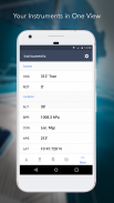
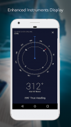
เครื่องมือวัดขั้นสูง
• รองรับข้อมูล NMEA ผ่าน TCP/IP (โดยใช้ Wifi)
• รวมเข้ากับ GPS ภายนอก, เครื่องรับ AIS และช่องสัญญาณ
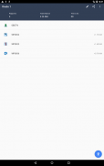
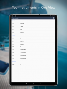
• เชื่อมต่อเครื่องมือเดินเรือ: ความลึก ความเร็ว ลม เครื่องยนต์ แบตเตอรี่ ฯลฯ
ชุดเครื่องมือที่จำเป็น
• พยากรณ์อากาศ GRib
• กระแสน้ำ/กระแสน้ำ
• สัญญาณเตือนสมอ
• การรวมระบบ AIS
• ค้นหาพอร์ต/นำทาง
ดาวน์โหลด iNavX TODAY และรับสำเนาฟรีของแผนภูมิแรสเตอร์ทางทะเลที่มีความละเอียดสูงอย่างเป็นทางการและทันสมัยของ NOAA RNC United States สหรัฐอเมริกา
บทวิจารณ์
“iNavX เป็นแอพการนำทางดั้งเดิมและยังคงเป็นหนึ่งในแอพนำทางที่ดีที่สุด”
– กะลาสีฝึกหัด
“แอพนำทางที่มีคุณสมบัติครบถ้วนที่สุดและคนจำนวนมากมองว่าเป็นมาตรฐาน”
– นิตยสาร Sail
"แอปสร้างแผนภูมิทางทะเลอันดับ 1 ที่แนะนำ"
- iMarineApps
iNavX ใช้งานได้กับ: C-MAP, Theyr Weather, Waterway Guide, AIS, Brookhouse, DigitalYacht, ShipModul, vYacht, Vesper Marine, NMEA 2000, Chetco และอื่นๆ
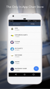
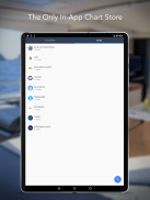
ใหม่ร้านค้าแผนภูมิ
ซื้อชาร์ตที่คุณชื่นชอบทั้งหมด การสมัครใช้งานแผนภูมิจะแตกต่างกันไปตามแผนภูมิและผู้ให้บริการ ตั้งแต่ $9.99 ถึง $199.99 ต่อปี โดยจะเรียกเก็บจากบัญชี iTunes ของคุณ ซึ่งจะต่ออายุโดยอัตโนมัติ เว้นแต่จะยกเลิกอย่างน้อย 24 ชั่วโมงก่อนสิ้นสุดระยะเวลาปัจจุบัน คุณสามารถปิดการต่ออายุอัตโนมัติได้ทุกเมื่อโดยไปที่การตั้งค่าบัญชีของคุณใน iTunes หลังจากซื้อ ไม่อนุญาตให้ยกเลิกการสมัครสมาชิกปัจจุบันในช่วงระยะเวลาการสมัครใช้งาน
หมายเหตุ: การใช้ GPS อย่างต่อเนื่องในพื้นหลังอาจทำให้อายุการใช้งานแบตเตอรี่สั้นลงอย่างมาก
ข้อมูลเพิ่มเติม
เว็บไซต์: http://inavx.com/
คู่มือผู้ใช้: http://inavx.com/help/
เงื่อนไขการใช้งาน: http://inavx.com/terms
นโยบายความเป็นส่วนตัว: http://inavx.com/privacy
iNavX: Marine Navigation--เวอร์ชั่น1.6.6
(03-08-2024)
iNavX: Marine Navigation - ข้อมูล APK
เวอร์ชั่น APK: 1.6.6แพ็คเกจ: com.gpsnavx.iNavXเวอร์ชั่นล่าสุดของiNavX: Marine Navigation
เวอร์ชั่นอื่น


 3.94
3.94


แอปในประเภทเดียวกัน


